Examining Atlas 14’s Impact on Future Development in the Houston Area
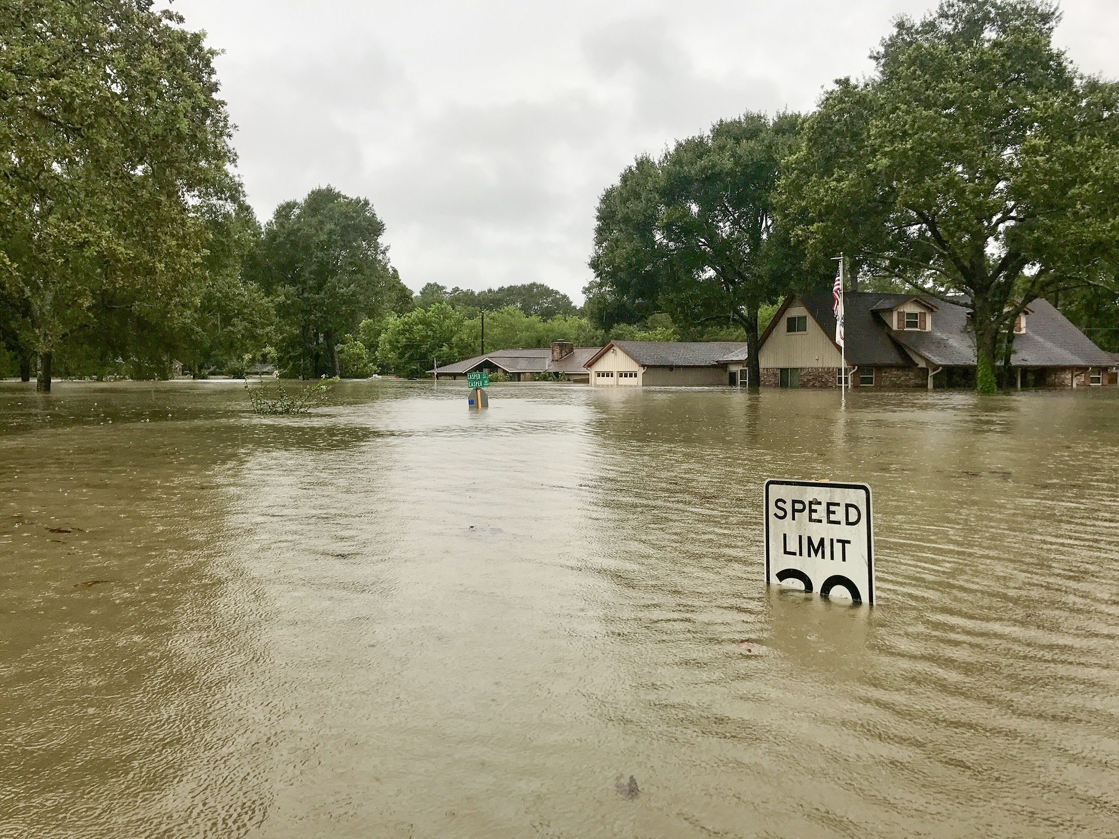
In 2017, Hurricane Harvey hit the Texas coast as a Category 4 hurricane and devastated the Houston area.
The National Oceanic and Atmospheric Administration (NOAA) published Atlas 14 (Volume 11) in 2018 to revise rainfall amounts that define a 100-year storm event—as well as other storm frequencies—in Texas.
The revised precipitation frequency analysis pushed the 100-year rainfall depths in Houston from an average of 13 inches to as much as 18 inches for a 24-hour period. That significant change resulted in new 100-year rainfall depths that nearly equal the previous 500-year depths.
Many local jurisdictions responded, including the City of Houston, to adopt Atlas 14 data to influence design criteria and make a critical shift toward long-term flood risk mitigation. The City of Houston revised Chapter 19 (Floodplains) of its Code of Ordinances to ensure new dwellings are constructed high enough to protect properties from flooding by requiring development to be constructed above the current regulatory FEMA 500-year flood elevations. The Harris County Flood Control District (HCFCD) and Harris County Engineering Department (HCED) implemented revisions to development regulations, calling for unincorporated areas of Harris County to build above the current regulatory FEMA 500-year flood elevations.
The Houston area has experienced a “500-year flood”—a flood that has a 1-in-500 chance of occurring within a given year—three times since 2015. However, most of those events impacted a specific area in the region. The one notable exception, of course, was Hurricane Harvey, which was widespread and at its peak resulted in about a third of Houston underwater.
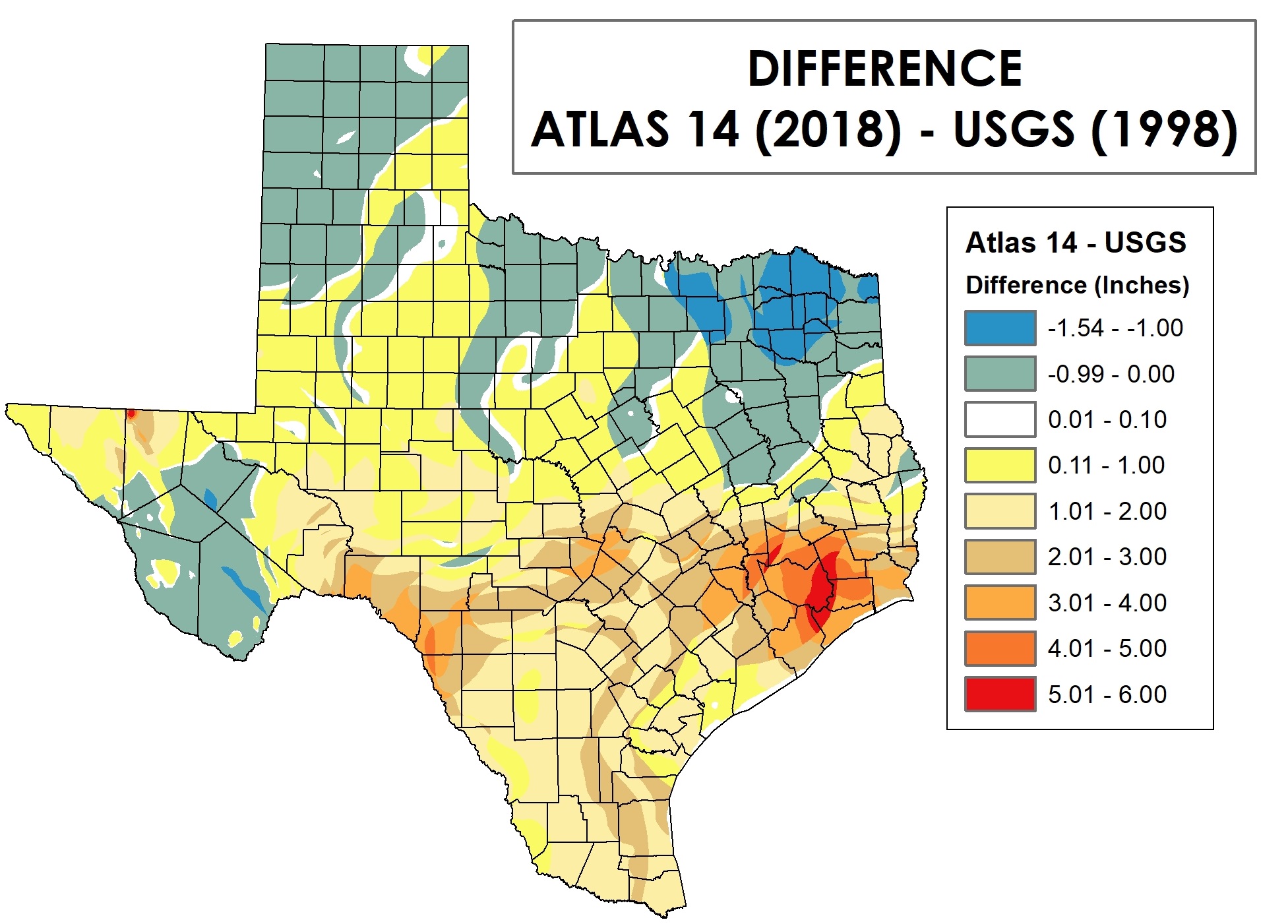
The map shows the difference in precipitation values (24-hour/100-year precipitation) in Texas between the USGS (1998) and Atlas 14 (2018) publications.
More About Atlas 14
NOAA Atlas 14, which was a nationwide study (Texas encompasses Volume 11), incorporated more historical data than the previous rainfall data set to provide a better representation of historical rainfall patterns.
The updated findings incorporated the 2017 rainfall data from Hurricane Harvey, from which the region is still recovering. Precipitation values increased for all rainfall frequency events within Atlas 14, but more significant increases were made for less frequent events: the 100-year and 500-year impacts. Harris County rainfall depths increased by 3 to 5 inches for the 100-year event.
In summary, NOAA said the new values are more accurate because of decades of additional rainfall data, an increase in the amount of available data and improved methods used in the analysis.
New Regulations Adopted
NOAA’s rainfall frequency values, which comprise the most recent update since the U.S. Geological Survey’s Depth-Duration Frequency of Precipitation for Texas report in 1998, have helped local authorities better understand their flood risk and more accurately plan and design infrastructure to minimize the threat and effects of flooding.
The current regulatory FEMA floodplain maps do not yet incorporate Atlas 14 rainfall. As a result, many jurisdictions are using 500-year flood elevations for setting minimum finished floor elevations and determining floodplain fill mitigation. In addition, many jurisdictions are requiring additional freeboard for buildings to reduce flood risk. For example, the City of Houston uses the 500-year elevation plus 2 feet for finished floor elevations. Harris County uses the 500-year elevation plus 2 feet for finished floor elevations for properties below the effective 100-year elevation.

The City of Houston, Harris County and HCFCD have also made changes to their floodplain fill mitigation requirement. The previous requirement included mitigation at 1:1 for fill placed below the effective 100-year elevation. These entities now require floodplain fill mitigation at 1:1 for fill placed below the 500-year elevation, thus increasing the required mitigation volume.
Harris County’s Modeling, Assessment and Awareness Project (MAAPnext) is also an endeavor aimed at developing the next generation of flood mapping. It’s a concerted effort to manage and regulate the county’s floodplains, informing residents about their risks and furthering resilience in the region. It will also provide comprehensive flood risk tools used to develop future growth, development and mitigation strategies.

Understanding the Impacts
What are the implications? Developers have more due-diligence work in front of them as they consider new opportunities to fully understand the impacts of these changes to proposed properties.
-
Increased precipitation depths contribute to increased runoff, and previously constructed outfall systems have already proven to be inadequate in some drainage areas. Developers will spend more on infrastructure costs, such as increased pipe sizes and detention volumes, to meet stormwater improvement requirements.
-
Developers may need to acquire more property to meet the revised detention and floodplain fill requirements. This will also impact site work costs.
Flood resiliency is an evolving priority. Halff’s innovative technical experts and designers can help you identify issues and design long-term solutions. Write to Info@Halff.com for more guidance on Atlas 14 and its impact on your development.
ABOUT HALFF
Halff is an award-winning Texas-based, employee-owned, diverse and full-service professional services firm. For 70 years, Halff has provided innovative solutions for clients in Texas and throughout the United States, offering full-service planning, engineering, architecture, landscape architecture, environmental, oil and gas, right of way, visualization and surveying services. Halff has 25 offices in Texas, Arkansas, Oklahoma, Louisiana and Florida. The firm is ranked No. 106 by Engineering News-Record.
Recent Stories

Halff Receives ACEC Florida FDOT Outstanding Project Award
CRESTVIEW, Fla. — The SR 30 Pedestrian Underpass at the Inlet Beach project was presented with the Outstanding Project Award in…

How Resilience Planning Helps Communities Adapt and Strengthen
Resilience planning has become a critical focus in response to today’s unprecedented environmental challenges and billion-dollar climate disasters, which demand…